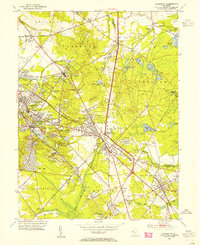
1953 Map of Clementon
USGS Topo · Published 1954About this map
The Pennsylvania-Reading Seashore Lines provides the structural backbone for this mid-century landscape, linking a string of established settlements from Gibbsboro and Lindenwold down to Berlin and Atco. The dominance of the White Horse Pike as a primary thoroughfare reflects the era's post-war automotive growth, though the region retains its agricultural and industrial roots. Extensive Cranberry Bogs dot the eastern reaches in Evesham, particularly near Barton Run. Small-scale aviation is represented by both Echelon Airport and Clementon Airport, marking a time before suburban consolidation. Local heritage is preserved in the location of the Watsontown School and Trinity Church, while the numerous named lakes like Lake Worth and Clementon Lake highlight the area's developed water resources and recreational spaces, such as the Pine Hill Boy Scout Camp.
Find a feature on this map
82 named features on this map. Tap any name to fly to it.
Don’t see what you’re looking for? This feature index may not catch every label — zoom into the map to look around manually.
Map Details
Editions of this 1953 Clementon Map
3 editions found
Other maps of this area

1888 · Mount Holly
USGS Topo · 1:62,500

1890 · Hammonton
USGS Topo · 1:62,500

1890 · Glassboro
USGS Topo · 1:62,500

1891 · Philadelphia
USGS Topo · 1:62,500

1894 · Hammonton
USGS Topo · 1:62,500

1894 · Mount Holly
USGS Topo · 1:62,500

1894 · Philadelphia
USGS Topo · 1:62,500

1896 · Philadelphia
USGS Topo · 1:62,500

1898 · Glassboro
USGS Topo · 1:62,500

1898 · Philadelphia
USGS Topo · 1:62,500