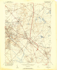
1953 Map of Clementon
USGS Topo · Published 1954About this map
The Pennsylvania-Reading Seashore Lines define the transit corridor of Camden County, linking together a chain of communities from Gibbsboro and Lindenwold down to Berlin and Atco. This mid-century survey reveals a landscape of transition where early industrial sites like Tomlinson Mill and various Cranberry Bogs coexist with growing suburban hubs and local infrastructure like the Echelon Airport and Clementon Airport. The map traces the headwaters of several critical New Jersey waterways, including the North Br Cooper River, the Mullica River, and the Great Egg Harbor River. Cultural landmarks such as the Pine Hill Boy Scout Camp, Trinity Ch, and several rural schoolhouses like the Watsontown Sch provide essential geographic markers for genealogists. The road network is anchored by the White Horse Pike, illustrating the area's development before the full expansion of the modern highway system.
Find a feature on this map
87 named features on this map. Tap any name to fly to it.
Don’t see what you’re looking for? This feature index may not catch every label — zoom into the map to look around manually.
Map Details
Editions of this 1953 Clementon Map
3 editions found
Other maps of this area

1888 · Mount Holly
USGS Topo · 1:62,500

1890 · Hammonton
USGS Topo · 1:62,500

1890 · Glassboro
USGS Topo · 1:62,500

1891 · Philadelphia
USGS Topo · 1:62,500

1894 · Hammonton
USGS Topo · 1:62,500

1894 · Mount Holly
USGS Topo · 1:62,500

1894 · Philadelphia
USGS Topo · 1:62,500

1896 · Philadelphia
USGS Topo · 1:62,500

1898 · Glassboro
USGS Topo · 1:62,500

1898 · Philadelphia
USGS Topo · 1:62,500