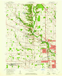
1959 Map of Clermont
USGS Topo · Published 1961About this map
Eagle Creek carves a deep wooded corridor through this 1950s landscape, serving as a natural boundary between the expanding suburbs of Indianapolis and the rural reaches of Pike and Lincoln townships. The map documents a critical period of mid-century growth, where new residential developments like Meadowood and Eagledale press against established settlements such as Clermont and the curiously named Snacks. This transition is most evident in the east, where the massive infrastructure of the Speedway racing grounds and the Indiana Girls Sch contrast with the family plots and country parishes like Bullard Cem and North Liberty Ch. Transportation networks define the era, with the Pennsylvania Railroad and the New York Central Railroad bisecting the terrain alongside burgeoning motor routes like Crawfordsville Road, illustrating a county in the midst of suburban transformation.
Find a feature on this map
96 named features on this map. Tap any name to fly to it.
Don’t see what you’re looking for? This feature index may not catch every label — zoom into the map to look around manually.
Map Details
Editions of this 1959 Clermont Map
This is the sole edition of this map. No revisions or reprints were ever made.
Other maps of this area

1948 · Maywood
USGS Topo · 1:24,000

1948 · Indianapolis West
USGS Topo · 1:24,000

1952 · Carmel
USGS Topo · 1:24,000

1953 · Bridgeport
USGS Topo · 1:24,000

1953 · Fayette
USGS Topo · 1:24,000

1953 · Brownsburg
USGS Topo · 1:24,000

1953 · Zionsville
USGS Topo · 1:24,000

1953 · Plainfield
USGS Topo · 1:24,000

1953 · Clermont
USGS Topo · 1:24,000

1953 · Indianapolis
USGS Topo · 1:250,000