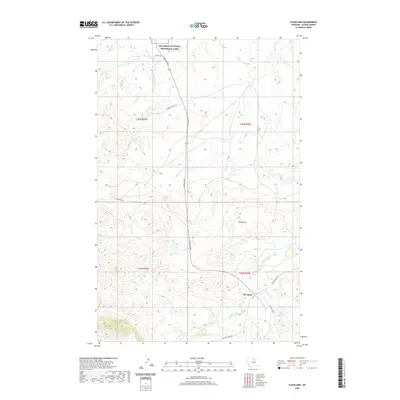
2020 Map of Cleveland
USGS Topo · Published 2020About this map
Cleveland lies at the intersection of Cleveland Rd and Nicholson-Bluff Rd in this northern Montana landscape, where the prairie meets the northern foothills. The area is defined by its complex drainage network, primarily the westward flow of Peoples Cr and its tributaries like Cleveland Cr and Schultz Cr. To the north, a portion of the Nez Perce National Historical Park is preserved, including the upper reaches of Snake Cr. The terrain is marked by distinctive geological features such as the Crown Butte ridge and the Sand Rocks formation. Local water management is evident through the Faber Reservoir and Ross Lake, reflecting the agricultural and ranching reliance on these seasonal water sources. Roads like Gordon Cattle Ln and HC Kuhr Ln suggest the importance of local ranching operations in this part of Blaine County.
Find a feature on this map
27 named features on this map. Tap any name to fly to it.
Don’t see what you’re looking for? This feature index may not catch every label — zoom into the map to look around manually.
Map Details
Editions of this 2020 Cleveland Map
This is the sole edition of this map. No revisions or reprints were ever made.
Other maps of this area

1953 · Havre
USGS Topo · 1:250,000

1956 · Maddux
USGS Topo · 1:62,500

1956 · Rattlesnake
USGS Topo · 1:62,500

1956 · Lloyd
USGS Topo · 1:62,500

1956 · Cleveland
USGS Topo · 1:62,500

1957 · Havre
USGS Topo · 1:250,000

1958 · Havre
USGS Topo · 1:250,000
1987 · Cleveland NW
USGS Topo · 1:24,000
1987 · Sayer Butte
USGS Topo · 1:24,000
1987 · Cleveland
USGS Topo · 1:24,000