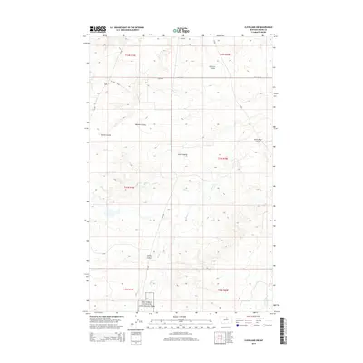
2014 Map of Cleveland NW
USGS Topo · Published 2014About this map
Nez Perce National Historical Park extends into the southern reaches of this Blaine County landscape, marking a site of significant cultural and historical weight. The terrain is defined by a series of dramatic coulees, including Lonetree Coulee, Sixmile Coulee, and Willman Coulee, which channel the drainage of the northern plains toward seasonal waterways. Evidence of the region's energy economy is clear at the Bowes Oil Field in the northwest, where Oil Field Loop and Citation Ln service local operations. This 2014 survey captures a sparsely populated but active ranching and resource-rich area, where the winding courses of Snake Cr and Bean Cr cut through the high prairie, illustrating the complex relationship between the natural topography and the human efforts to navigate and utilize this expansive Montana environment.
Find a feature on this map
21 named features on this map. Tap any name to fly to it.
Don’t see what you’re looking for? This feature index may not catch every label — zoom into the map to look around manually.
Map Details
Editions of this 2014 Cleveland NW Map
This is the sole edition of this map. No revisions or reprints were ever made.
Other maps of this area

1904 · Yantic
USGS Topo · 1:62,500

1904 · Chinook
USGS Topo · 1:62,500

1912 · Zurich
USGS Topo · 1:125,000

1953 · Havre
USGS Topo · 1:250,000

1956 · Lloyd
USGS Topo · 1:62,500

1956 · Cleveland
USGS Topo · 1:62,500

1957 · Havre
USGS Topo · 1:250,000

1958 · Havre
USGS Topo · 1:250,000
1964 · Lohman SE
USGS Topo · 1:24,000
1964 · Chinook
USGS Topo · 1:24,000