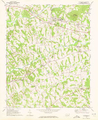
1970 Map of Cleveland
USGS Topo · Published 1972About this map
Cleveland serves as a central hub on this West Rowan landscape, situated where the Southern railroad traverses a network of waterways including Third Creek and Beaverdam Creek. The settlement pattern in the early 1970s reflects a rural Piedmont community anchored by long-standing institutions like Lebanon Ch and Knox Chapel. Significant for local historians, the map documents the community infrastructure of the era, from the West Rowan High Sch to the Lookout Tower on Youngs Mtn.
Find a feature on this map
33 named features on this map. Tap any name to fly to it.
Don’t see what you’re looking for? This feature index may not catch every label — zoom into the map to look around manually.
Map Details
Editions of this 1970 Cleveland Map
2 editions found
Other maps of this area

1893 · Statesville
USGS Topo · 1:125,000

1953 · Charlotte
USGS Topo · 1:250,000

1954 · Charlotte
USGS Topo · 1:250,000

1960 · Charlotte
USGS Topo · 1:250,000

1962 · Charlotte
USGS Topo · 1:250,000

1969 · Cooleemee
USGS Topo · 1:24,000

1969 · Cool Springs
USGS Topo · 1:24,000

1969 · Shepherds
USGS Topo · 1:24,000
1969 · Mooresville
USGS Topo · 1:24,000
1969 · Rowan Mills
USGS Topo · 1:24,000