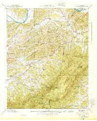
1940 Map of Clevenger
USGS Topo · Published 1940About this map
English Mountain dominates the southern landscape of this East Tennessee region, where the borders of Jefferson, Sevier, and Cocke counties meet. The high ridges, including The Pinnacle and The Lookoff, are contrasted by the fertile lowlands of Dutch Bottoms and the winding course of the French Broad River. This 1939 field examination by the Tennessee Valley Authority records a rural society defined by its local institutions and natural landmarks, such as the Blowing Cave Mill and Blowing Cave near the North Fork Flat Creek.
Find a feature on this map
75 named features on this map. Tap any name to fly to it.
Don’t see what you’re looking for? This feature index may not catch every label — zoom into the map to look around manually.
Map Details
Editions of this 1940 Clevenger Map
2 editions found
Other maps of this area

1883 · Morristown
USGS Topo · 1:125,000

1893 · Mt Guyot
USGS Topo · 1:125,000

1893 · Morristown
USGS Topo · 1:125,000

1895 · Morristown
USGS Topo · 1:125,000

1912 · Mt Guyot
USGS Topo · 1:125,000

1935 · Newport
USGS Topo · 1:48,000

1935 · White Pine
USGS Topo · 1:24,000

1935 · Hartford
USGS Topo · 1:24,000

1935 · English Mountain
USGS Topo · 1:48,000

1935 · Clevenger
USGS Topo · 1:24,000