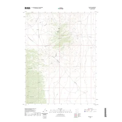
2023 Map of Clifton
USGS Topo · Published 2023About this map
The Deep Creek Range defines this high-desert landscape in Tooele County, where the settlement of Clifton sits amidst a network of historic transportation corridors. The map clearly delineates the Pony Express-Overland Stage Trl, a vital historical artery that runs near Clifton Flat and through Overland Canyon. This modern topographic survey by the U.S. Geological Survey captures the rugged relief of several prominent summits, including Montezuma Peak, Blood Mtn, and Abercrombie Peak. Water sources, critical in this arid environment, are documented at Willow Spring, Goshute Spring, and Minnehaha Spring. Local industry and transit history are further evidenced by names such as Monocco Mine Rd and Montezumas Revenge Rd, providing a detailed look at the geographic names and land use patterns preserved into the twenty-first century.
Find a feature on this map
36 named features on this map. Tap any name to fly to it.
Don’t see what you’re looking for? This feature index may not catch every label — zoom into the map to look around manually.
Map Details
Editions of this 2023 Clifton Map
This is the sole edition of this map. No revisions or reprints were ever made.
Other maps of this area

1908 · Fish Springs
USGS Topo · 1:250,000

1910 · Fish Springs
USGS Topo · 1:250,000

1925 · Gold Hill
USGS Topo · 1:62,500

1928 · Gold Hill
USGS Topo · 1:62,500

1953 · Tooele
USGS Topo · 1:250,000

1953 · Delta
USGS Topo · 1:250,000

1955 · Tooele
USGS Topo · 1:250,000

1958 · Delta
USGS Topo · 1:250,000

1962 · Delta
USGS Topo · 1:250,000
1972 · Goshute Canyon
USGS Topo · 1:24,000