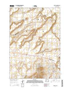
2014 Map of Cline Falls
USGS Topo · Published 2014About this map
Eagle Crest serves as the primary residential development in this high-desert landscape, situated just west of the winding Deschutes River. The terrain is defined by dramatic volcanic features and deep erosional cuts, including the sheer walls of Deschutes Canyon and Buckhorn Canyon in the north. Significant landmarks such as Steamboat Rock and the prominent Cline Buttes rise above the sagebrush plains, while water features like Big Falls and Odin Falls mark the river's descent. The area's aviation history is visible through two distinct facilities: the larger Cline Falls Air Park near the river and the more isolated The Citadel Airport to the west. This map illustrates the intersection of modern suburban expansion with ancient geological formations like Bessie Butte and LaFollette Butte, providing a detailed look at the infrastructure that has grown around these natural barriers.
Find a feature on this map
80 named features on this map. Tap any name to fly to it.
Don’t see what you’re looking for? This feature index may not catch every label — zoom into the map to look around manually.
Map Details
Editions of this 2014 Cline Falls Map
This is the sole edition of this map. No revisions or reprints were ever made.
Other maps of this area

1926 · Bend
USGS Topo · 1:125,000

1929 · Bend
USGS Topo · 1:125,000

1955 · Bend
USGS Topo · 1:250,000

1957 · Bend
USGS Topo · 1:250,000

1958 · Bend
USGS Topo · 1:250,000

1961 · Redmond
USGS Topo · 1:24,000

1962 · Opal City
USGS Topo · 1:24,000

1962 · Forked Horn Butte
USGS Topo · 1:24,000
1962 · Redmond
USGS Topo · 1:24,000
1962 · Cline Falls
USGS Topo · 1:24,000