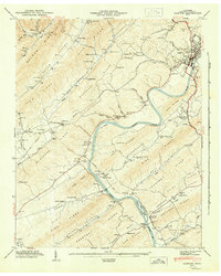
1946 Map of Clinton
USGS Topo · Published 1946About this map
Clinton sits at a critical junction of rail and river, where the Southern and Louisville And Nashville railroads parallel the winding Clinch River. This 1940s landscape is defined by the repetitive ridge-and-valley topography of eastern Tennessee, with named landforms like Blackoak Ridge and Pine Ridge separating narrow inhabited corridors. Small agrarian settlements and family nodes such as Dutch Valley, Leinarts, and Marlow are scattered throughout these corridors, often centered around local landmarks like Spessard Mill or rural congregations like New Salem Ch and Liberty Ch.
Find a feature on this map
77 named features on this map. Tap any name to fly to it.
Don’t see what you’re looking for? This feature index may not catch every label — zoom into the map to look around manually.
Map Details
Editions of this 1946 Clinton Map
2 editions found
Other maps of this area

1893 · Briceville
USGS Topo · 1:125,000

1895 · Loudon
USGS Topo · 1:125,000

1895 · Briceville
USGS Topo · 1:125,000

1896 · Briceville
USGS Topo · 1:125,000

1935 · Bethel Valley
USGS Topo · 1:24,000

1935 · Bearden
USGS Topo · 1:24,000

1935 · Lovell
USGS Topo · 1:24,000

1936 · Duncan Flats
USGS Topo · 1:24,000

1936 · Windrock
USGS Topo · 1:24,000

1936 · Norris Dam
USGS Topo · 1:48,000