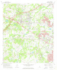
1971 Map of Clinton
USGS Topo · Published 1973About this map
Mississippi College serves as a central anchor for the town of Clinton, where the historical Natchez Trace Parkway and the Illinois Central railroad corridor intersect. This early 1970s landscape reveals a mix of academic tradition at the Clinton Academy and federal presence at the U S Army Engineer Waterways Experiment Station. Beyond the expanding residential blocks of Jackson, the surrounding Hinds County countryside is dotted with small rural landmarks like Summer Hill Sch & Ch and Flag Chapel.
Find a feature on this map
79 named features on this map. Tap any name to fly to it.
Don’t see what you’re looking for? This feature index may not catch every label — zoom into the map to look around manually.
Map Details
Editions of this 1971 Clinton Map
This is the sole edition of this map. No revisions or reprints were ever made.
Other maps of this area

1903 · Jackson
USGS Topo · 1:125,000

1905 · Jackson
USGS Topo · 1:48,000

1906 · Florence
USGS Topo · 1:62,500

1908 · Jackson
USGS Topo · 1:62,500

1908 · Florence
USGS Topo · 1:62,500

1934 · Raymond
USGS Topo · 1:48,000

1937 · Raymond
USGS Topo · 1:62,500

1937 · Terry
USGS Topo · 1:48,000

1942 · Raymond
USGS Topo · 1:62,500

1943 · Terry
USGS Topo · 1:62,500