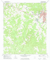
1971 Map of Clinton
USGS Topo · Published 1975About this map
The textile and educational hubs of Clinton and Laurens anchor this upstate South Carolina landscape in the early 1970s. The dense street grid of Clinton is dominated by the campus of Presbyterian College and the industrial activity near Lydia Mills. The Seaboard Coast Line railroad cuts a diagonal path through the terrain, connecting these manufacturing centers to the wider region. Outside the municipal centers, the map reveals a rural geography defined by a network of local congregations such as Holly Grove Ch and New China Ch, reflecting the deep-seated community structures of Laurens County.
Find a feature on this map
35 named features on this map. Tap any name to fly to it.
Don’t see what you’re looking for? This feature index may not catch every label — zoom into the map to look around manually.
Map Details
Editions of this 1971 Clinton Map
This is the sole edition of this map. No revisions or reprints were ever made.
Other maps of this area

1892 · Abbeville
USGS Topo · 1:125,000

1941 · Spartanburg
USGS Topo · 1:250,000

1953 · Spartanburg
USGS Topo · 1:250,000

1954 · Greenville
USGS Topo · 1:250,000

1957 · Fountain Inn
USGS Topo · 1:62,500

1958 · Greenville
USGS Topo · 1:250,000

1960 · Spartanburg
USGS Topo · 1:250,000

1963 · Spartanburg
USGS Topo · 1:250,000

1964 · Spartanburg
USGS Topo · 1:250,000

1969 · Ora
USGS Topo · 1:24,000