
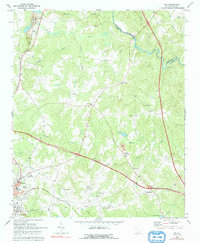
1969 Map of Ora
USGS Topo · Published 1972About this map
Wattsville and the northern outskirts of Laurens anchor the southern edge of this landscape, where the Columbia Newberry And Laurens line meets the rolling Piedmont terrain. The area is characterized by a network of rural communities and historic congregations, including Sandy Springs Ch, Duncan Creek Ch, and Mount Vernon Ch. The Enoree River winds along the eastern boundary, serving as the border between Spartanburg and Laurens counties.
Find a feature on this map
41 named features on this map. Tap any name to fly to it.
Don’t see what you’re looking for? This feature index may not catch every label — zoom into the map to look around manually.
Map Details
Editions of this 1969 Ora Map
2 editions found
Other maps of this area

1892 · Abbeville
USGS Topo · 1:125,000

1941 · Spartanburg
USGS Topo · 1:250,000

1953 · Spartanburg
USGS Topo · 1:250,000

1954 · Greenville
USGS Topo · 1:250,000

1957 · Fountain Inn
USGS Topo · 1:62,500

1958 · Greenville
USGS Topo · 1:250,000

1960 · Spartanburg
USGS Topo · 1:250,000

1963 · Spartanburg
USGS Topo · 1:250,000

1964 · Spartanburg
USGS Topo · 1:250,000

1969 · Cross Anchor
USGS Topo · 1:24,000