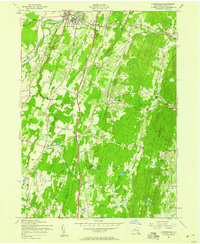
1957 Map of Clintondale
USGS Topo · Published 1958About this map
The Wallkill River winds through the northwestern corner of this Hudson Valley landscape, where the growing campus of the State Teachers College anchors the village of New Paltz. In the mid-1950s, the newly constructed New York State Thruway cuts a modern path north-to-south, bypassing older settlements and altering the rural character of orchards and family farms. This infrastructure stands in contrast to the established agricultural corridor served by the New York New Haven and Hartford railroad, which passes through Clintondale Sta.
Find a feature on this map
60 named features on this map. Tap any name to fly to it.
Don’t see what you’re looking for? This feature index may not catch every label — zoom into the map to look around manually.
Map Details
Editions of this 1957 Clintondale Map
Other maps of this area

1893 · Poughkeepsie
USGS Topo · 1:62,500

1894 · Poughkeepsie
USGS Topo · 1:62,500

1898 · Rhinebeck
USGS Topo · 1:62,500

1901 · Rosendale
USGS Topo · 1:62,500

1903 · Poughkeepsie
USGS Topo · 1:62,500

1903 · Newburg
USGS Topo · 1:62,500

1903 · Rosendale
USGS Topo · 1:62,500

1934 · Rhinebeck
USGS Topo · 1:48,000

1936 · Poughkeepsie
USGS Topo · 1:48,000

1939 · Rhinebeck
USGS Topo · 1:62,500