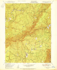
1950 Map of Clipper Mills
USGS Topo · Published 1950About this map
Clipper Mills and the high ridge country of the Northern Sierra Nevada appear here during a period of transition in the mid-century timber and mining industries. The map detail highlights the intersection of industrial work and rural life, featuring the Clipper Mills School alongside a functioning Sawmill and the Monte de Oro Mine. Further north, the legacy of earlier gold-seeking efforts is visible at the Triumph Mine, while family-named landmarks like Maynards Ranch and Bean Ranch indicate established mountain homesteads. The terrain is defined by the steep canyon of the Feather River, which flows through the Plumas National Forest. The presence of an extensive network of ditches, a Siphon, and a Canal near Jackass Flat underscores the complex water-management systems required to support both local resource extraction and larger downstream needs in Butte and Yuba counties.
Find a feature on this map
53 named features on this map. Tap any name to fly to it.
Don’t see what you’re looking for? This feature index may not catch every label — zoom into the map to look around manually.
Map Details
Editions of this 1950 Clipper Mills Map
2 editions found
Other maps of this area

1888 · Smartsville
USGS Topo · 1:125,000

1888 · Bidwell Bar
USGS Topo · 1:125,000

1891 · Bidwell Bar
USGS Topo · 1:125,000

1891 · Smartsville
USGS Topo · 1:125,000

1892 · Smartsville
USGS Topo · 1:125,000

1893 · Bidwell Bar
USGS Topo · 1:125,000

1894 · Smartsville
USGS Topo · 1:125,000

1895 · Bidwell Bar
USGS Topo · 1:125,000

1895 · Smartsville
USGS Topo · 1:125,000

1897 · Bidwell Bar
USGS Topo · 1:125,000