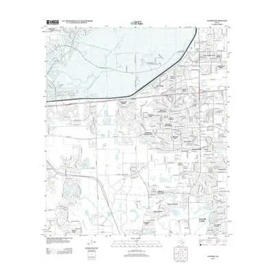
2013 Map of Clodine
USGS Topo · Published 2013About this map
The Barker Reservoir and the expansive wetlands of the Buffalo Bayou dominate the northern landscape of this Houston-area survey, illustrating the critical water management infrastructure of the region. The southern half reveals a transition into dense residential developments and named subdivisions that characterized the early 21st-century growth of Fort Bend and Harris Counties. Key communities like Clodine and Four Corners serve as hubs among a network of neighborhoods including Mission Bend South, Providence, and Summerfield. Drainage patterns are clearly defined by the winding paths of Oyster Cr and Keegans Bayou, which snake through the suburban layout. The inclusion of the Westpark Tollway and the Barker Dam highlights the intersection of modern transportation and massive flood control projects essential to the stability of this low-lying Texas coastal plain terrain.
Find a feature on this map
49 named features on this map. Tap any name to fly to it.
Don’t see what you’re looking for? This feature index may not catch every label — zoom into the map to look around manually.
Map Details
Editions of this 2013 Clodine Map
This is the sole edition of this map. No revisions or reprints were ever made.
Other maps of this area

1915 · Alief
USGS Topo · 1:24,000

1915 · Katy
USGS Topo · 1:24,000

1915 · Addicks
USGS Topo · 1:24,000

1915 · Hillendahl
USGS Topo · 1:24,000

1915 · Clodine
USGS Topo · 1:24,000

1918 · Addicks
USGS Topo · 1:31,680

1918 · Hillendahl
USGS Topo · 1:31,680

1919 · Clodine
USGS Topo · 1:31,680

1950 · Houston
USGS Topo · 1:250,000
1955 · Addicks
USGS Topo · 1:62,500