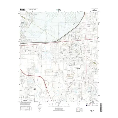
2016 Map of Clodine
USGS Topo · Published 2016About this map
Buffalo Bayou and Brays Bayou carve through this rapidly developing corridor of the Texas Gulf Coast, where the expansion of the Houston metro area meets established suburban enclaves and historical sites. The map documents the intricate street networks of Mission Bend and Cinco Ranch, illustrating the transition of agricultural land into master-planned communities. Aviation and industrial infrastructure are centered around the Sugar Land Regional Airport, while smaller landmarks like New Home Cem and Sebring Career Schools provide evidence of local social history. The southern reaches near Richmond are defined by the winding course of Oyster Creek and Bullhead Bayou, which separate neighborhoods like Pecan Grove from the central hub of Sugar Land. This 2016 snapshot captures the region just before the continued urbanization of the Harris and Fort Bend county line.
Find a feature on this map
40 named features on this map. Tap any name to fly to it.
Don’t see what you’re looking for? This feature index may not catch every label — zoom into the map to look around manually.
Map Details
Editions of this 2016 Clodine Map
This is the sole edition of this map. No revisions or reprints were ever made.
Other maps of this area

1915 · Alief
USGS Topo · 1:24,000

1915 · Katy
USGS Topo · 1:24,000

1915 · Addicks
USGS Topo · 1:24,000

1915 · Hillendahl
USGS Topo · 1:24,000

1915 · Clodine
USGS Topo · 1:24,000

1918 · Addicks
USGS Topo · 1:31,680

1918 · Hillendahl
USGS Topo · 1:31,680

1919 · Clodine
USGS Topo · 1:31,680

1950 · Houston
USGS Topo · 1:250,000
1955 · Addicks
USGS Topo · 1:62,500