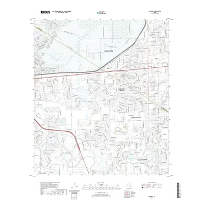
2019 Map of Clodine
USGS Topo · Published 2019About this map
Buffalo Bayou and Oyster Creek weave through a landscape transitioning from the suburban reaches of Houston and Sugar Land into the western drainage of Harris and Fort Bend Counties. The area is defined by a dense network of modern residential developments and significant infrastructure, including the Sugar Land Regional Airport and the George Bush Hike and Bike Trail which traverses the northern wetlands. Among the established neighborhoods of Mission Bend and Town West, local history remains anchored at the New Home Cemetery near the southern edge of the survey. The community of Clodine sits at a central transit junction, where FM 1093 and Alief Clodine Road meet, illustrating the suburban expansion that has bridged the space between the historic towns of Richmond and the Houston metroplex.
Find a feature on this map
26 named features on this map. Tap any name to fly to it.
Don’t see what you’re looking for? This feature index may not catch every label — zoom into the map to look around manually.
Map Details
Editions of this 2019 Clodine Map
This is the sole edition of this map. No revisions or reprints were ever made.
Other maps of this area

1915 · Alief
USGS Topo · 1:24,000

1915 · Katy
USGS Topo · 1:24,000

1915 · Addicks
USGS Topo · 1:24,000

1915 · Hillendahl
USGS Topo · 1:24,000

1915 · Clodine
USGS Topo · 1:24,000

1918 · Addicks
USGS Topo · 1:31,680

1918 · Hillendahl
USGS Topo · 1:31,680

1919 · Clodine
USGS Topo · 1:31,680

1950 · Houston
USGS Topo · 1:250,000
1955 · Addicks
USGS Topo · 1:62,500