
1915 Map of Clodine
USGS Topo · Published 1961About this map
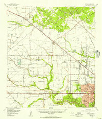
The settlement of Clodine marks the central landscape of this 1915 survey, situated along the San Antonio and Aransas Pass R R. This rail-oriented corridor, flanked by the Harris Co Fort Bend Co line, reveals the early infrastructure of the coastal prairie before modern suburban expansion. North of the primary line, the defunct route of the Texas Western R R (Abandoned) cuts across the terrain, indicating a shifting industrial landscape in the early twentieth century.
Find a feature on this map
10 named features on this map. Tap any name to fly to it.
Don’t see what you’re looking for? This feature index may not catch every label — zoom into the map to look around manually.
Map Details
Editions of this 1915 Clodine Map
This is the sole edition of this map. No revisions or reprints were ever made.
Other maps of this area

1915 · Alief
USGS Topo · 1:24,000

1915 · Katy
USGS Topo · 1:24,000

1915 · Addicks
USGS Topo · 1:24,000

1915 · Hillendahl
USGS Topo · 1:24,000

1918 · Addicks
USGS Topo · 1:31,680

1918 · Hillendahl
USGS Topo · 1:31,680

1919 · Clodine
USGS Topo · 1:31,680

1950 · Houston
USGS Topo · 1:250,000
1955 · Addicks
USGS Topo · 1:62,500

1955 · Sugar Land
USGS Topo · 1:62,500