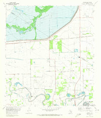
1970 Map of Clodine
USGS Topo · Published 1973About this map
Barker Reservoir and the Barker Dam dominate the northern landscape of this region, where the Harris and Fort Bend county lines meet. This 1970 snapshot of the terrain reveals a transition from the hydraulic management of Buffalo Bayou to the expansive State Prison Farm in the south along Oyster Creek. The Southern Pacific railroad cuts a diagonal line through the small settlement of Clodine, reflecting the historical importance of rail transit before the suburban expansion of Sugar Land began to reshape the area. Local social life is anchored by dispersed landmarks like Shiloh Ch, Pleasant Green Church, and Magee Chapel. The southern edge features Hull Field and several named water bodies, including Fish Lake and Gannoway Lake, illustrating a landscape shaped by both industrial prison labor and the winding waterways of the Gulf Coast plains.
Find a feature on this map
46 named features on this map. Tap any name to fly to it.
Don’t see what you’re looking for? This feature index may not catch every label — zoom into the map to look around manually.
Map Details
Editions of this 1970 Clodine Map
This is the sole edition of this map. No revisions or reprints were ever made.
Other maps of this area

1915 · Alief
USGS Topo · 1:24,000

1915 · Katy
USGS Topo · 1:24,000

1915 · Addicks
USGS Topo · 1:24,000

1915 · Hillendahl
USGS Topo · 1:24,000

1915 · Clodine
USGS Topo · 1:24,000

1918 · Addicks
USGS Topo · 1:31,680

1918 · Hillendahl
USGS Topo · 1:31,680

1919 · Clodine
USGS Topo · 1:31,680

1950 · Houston
USGS Topo · 1:250,000
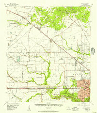
1955 · Addicks
USGS Topo · 1:62,500