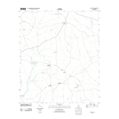
2011 Map of Clopton
USGS Topo · Published 2011About this map
Clopton serves as a primary reference point in this corner of Dale County, Alabama, where the local landscape is defined by its rural crossroads and family-held land. The community of Bertha and the surrounding area are crisscrossed by a network of county highways that connect numerous cemeteries, including Magnolia Cemetery and Mount Carmel Cemetery, which reflect generations of local residency. The West Fork Choctawhatchee River carves through the western portion of the region, spanned by the Monks Mill Bridge, while numerous tributaries like Stuckey Mill Creek and Panther Creek drain the undulating terrain. To the southeast, the G B Blankenship Dam forms Blankenship Pond along Riley Creek, marking a significant human-made modification to the natural drainage patterns of this agricultural and timber-producing region.
Find a feature on this map
49 named features on this map. Tap any name to fly to it.
Don’t see what you’re looking for? This feature index may not catch every label — zoom into the map to look around manually.
Map Details
Editions of this 2011 Clopton Map
This is the sole edition of this map. No revisions or reprints were ever made.
Other maps of this area

1942 · Enterprise
USGS Topo · 1:125,000

1948 · Ozark
USGS Topo · 1:62,500

1950 · Ozark
USGS Topo · 1:62,500

1953 · Dothan
USGS Topo · 1:250,000

1954 · Dothan
USGS Topo · 1:250,000

1955 · Dothan
USGS Topo · 1:250,000

1960 · Ewell
USGS Topo · 1:24,000
1962 · Ewell
USGS Topo · 1:25,000

1969 · Abbeville West
USGS Topo · 1:24,000
1969 · Clio
USGS Topo · 1:24,000