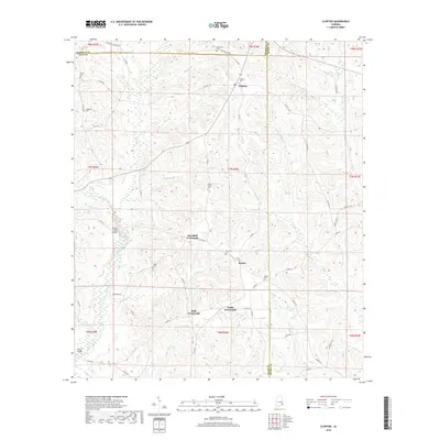
2018 Map of Clopton
USGS Topo · Published 2018About this map
The W Fork Choctawhatchee River defines the lower drainage of this landscape, where the intersections of Barbour, Dale, and Henry Counties meet. A network of rural hubs, including Barefield Crossroads, Bells Crossroads, and Snells Crossroads, centers the local geography around historic burial grounds and stream crossings. Genealogists will find several significant sites, such as New Hope Cem, Mount Carmel Cem, and Clopton Cem, which anchor the small communities of Bertha and Clopton. The presence of Monks Mill Bridge and Stuckey Mill Br suggests the importance of water-driven industry in the region's development. Numerous creeks, including Walnut Cr and Panther Cr, carve through the terrain, leading toward the Ward Bridge in the southwest corner of the quadrangle.
Find a feature on this map
69 named features on this map. Tap any name to fly to it.
Don’t see what you’re looking for? This feature index may not catch every label — zoom into the map to look around manually.
Map Details
Editions of this 2018 Clopton Map
This is the sole edition of this map. No revisions or reprints were ever made.
Other maps of this area

1942 · Enterprise
USGS Topo · 1:125,000

1948 · Ozark
USGS Topo · 1:62,500

1950 · Ozark
USGS Topo · 1:62,500

1953 · Dothan
USGS Topo · 1:250,000

1954 · Dothan
USGS Topo · 1:250,000

1955 · Dothan
USGS Topo · 1:250,000

1960 · Ewell
USGS Topo · 1:24,000
1962 · Ewell
USGS Topo · 1:25,000

1969 · Abbeville West
USGS Topo · 1:24,000
1969 · Clio
USGS Topo · 1:24,000