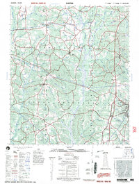
1997 Map of Clopton
USGS Topo · Published 1997About this map
The Choctawhatchee River and its numerous tributaries, including Lindsey Creek and Cedar Creek, define the landscape of this Henry County region in the late 1990s. The settlement of Abbeville serves as the primary hub in the southeast, anchored by a county hospital and infrastructure like Murphy Station. Rural life is centered around a dense network of community landmarks, particularly churches such as Bond Bethel Church, Macedonia Church, and St Michaels Church. Educational sites like the County Training School and St Peters School reflect the distributed nature of the local population. To the north, the terrain rises toward Rocky Mountain, while the west is dotted with agricultural water features such as Hartzog Pond and Lingo Pond. This survey details a transitional period for these Alabama communities, documenting established hamlets like Clopton, Edwin, and Texasville alongside modern utility developments like the local Substation.
Find a feature on this map
93 named features on this map. Tap any name to fly to it.
Don’t see what you’re looking for? This feature index may not catch every label — zoom into the map to look around manually.
Map Details
Editions of this 1997 Clopton Map
This is the sole edition of this map. No revisions or reprints were ever made.
Other maps of this area

1942 · Enterprise
USGS Topo · 1:125,000

1948 · Ozark
USGS Topo · 1:62,500

1950 · Ozark
USGS Topo · 1:62,500

1953 · Dothan
USGS Topo · 1:250,000

1954 · Dothan
USGS Topo · 1:250,000

1955 · Dothan
USGS Topo · 1:250,000

1960 · Ewell
USGS Topo · 1:24,000
1962 · Ewell
USGS Topo · 1:25,000

1967 · Clayton South
USGS Topo · 1:24,000

1968 · Baker Hill
USGS Topo · 1:24,000