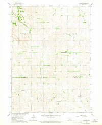
1963 Map of Closter
USGS Topo · Published 1964About this map
The agricultural landscape of the Nebraska high plains is meticulously detailed in this early 1960s survey, defined by the meeting of Antelope and Boone Counties. The small settlement of Closter serves as a local hub in the south, while the surrounding sections are dotted with rural infrastructure that speaks to a closely-knit farming community. A network of country schools, such as School No. 26 and Valley View School, are positioned to serve family farmsteads separated by the drainages of Saint Clair Creek and Cedar Creek. Genealogy interest is concentrated near the southern boundary, where the North Branch Zion Ch Cemetery and Zion West Cem provide critical records of early settlers. The mapping also reveals a distinct landscape of land management, with fine red dashed lines indicating specific fence and field lines visible from aerial photography in 1961.
Find a feature on this map
19 named features on this map. Tap any name to fly to it.
Don’t see what you’re looking for? This feature index may not catch every label — zoom into the map to look around manually.
Map Details
Editions of this 1963 Closter Map
2 editions found
Other maps of this area

1955 · Broken Bow
USGS Topo · 1:250,000

1955 · Sioux City
USGS Topo · 1:250,000

1955 · Fremont
USGS Topo · 1:250,000

1955 · O'Neill
USGS Topo · 1:250,000

1956 · Broken Bow
USGS Topo · 1:250,000

1957 · Fremont
USGS Topo · 1:250,000

1958 · Sioux City
USGS Topo · 1:250,000

1958 · Fremont
USGS Topo · 1:250,000

1959 · O'Neill
USGS Topo · 1:250,000

1959 · Sioux City
USGS Topo · 1:250,000