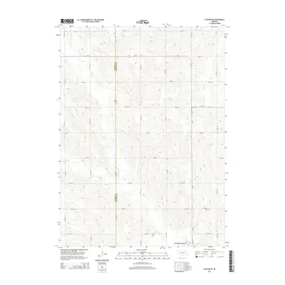
2014 Map of Closter SE
USGS Topo · Published 2014About this map
Newman Grove sits at the southern edge of this Madison County landscape, where the agricultural grid meets the winding course of Shell Cr. The area is defined by its drainage systems, including the northern branch of N Shell Cr and the seasonal paths of Dry Cr and Battle Cr. These waterways historically dictated the placement of early settlements and rural infrastructure across the Nebraska plains.
Find a feature on this map
35 named features on this map. Tap any name to fly to it.
Don’t see what you’re looking for? This feature index may not catch every label — zoom into the map to look around manually.
Map Details
Editions of this 2014 Closter SE Map
This is the sole edition of this map. No revisions or reprints were ever made.
Other maps of this area

1955 · Fremont
USGS Topo · 1:250,000

1957 · Fremont
USGS Topo · 1:250,000

1958 · Fremont
USGS Topo · 1:250,000

1958 · Albion East
USGS Topo · 1:24,000

1963 · Closter SW
USGS Topo · 1:24,000

1963 · Emerick
USGS Topo · 1:24,000

1963 · Closter SE
USGS Topo · 1:24,000
1963 · Closter
USGS Topo · 1:24,000
1963 · Closter NE
USGS Topo · 1:24,000

1963 · Battle Creek SW
USGS Topo · 1:24,000