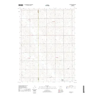
2017 Map of Closter SE
USGS Topo · Published 2017About this map
Newman Grove anchors the southeastern corner of this landscape, situated along the county line where Boone Co meets Madison County. This agricultural region is defined by the drainage basins of several meandering waterways, including Shell Creek and its tributary North Shell Creek, which carve through the plains. The map reveals a strictly regulated section-line road network typical of the Great Plains, where routes like State Hwy 45 and numerous numbered avenues such as 330th Ave and 535 Ave provide access to dispersed farmsteads. Local heritage is preserved in the placement of small rural burial grounds like Shell Creek Cem and Trinity Cem, which remain as physical markers of the area's early settlement history and community genealogy near the banks of Dry Creek.
Find a feature on this map
41 named features on this map. Tap any name to fly to it.
Don’t see what you’re looking for? This feature index may not catch every label — zoom into the map to look around manually.
Map Details
Editions of this 2017 Closter SE Map
This is the sole edition of this map. No revisions or reprints were ever made.
Other maps of this area

1955 · Fremont
USGS Topo · 1:250,000

1957 · Fremont
USGS Topo · 1:250,000

1958 · Fremont
USGS Topo · 1:250,000

1958 · Albion East
USGS Topo · 1:24,000

1963 · Closter SW
USGS Topo · 1:24,000

1963 · Emerick
USGS Topo · 1:24,000

1963 · Closter SE
USGS Topo · 1:24,000
1963 · Closter
USGS Topo · 1:24,000
1963 · Closter NE
USGS Topo · 1:24,000

1963 · Battle Creek SW
USGS Topo · 1:24,000