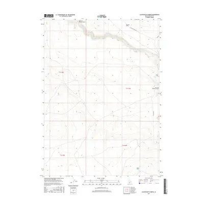
2017 Map of Clover Butte North
USGS Topo · Published 2017About this map
East Fork Bruneau Canyon carves a deep, winding path through the basaltic landscape of Owyhee County, defining the drainage patterns of this high desert terrain. The arid plains of the Bruneau Desert dominate the northeast, where the seasonal flow of Clover Creek meanders toward the canyon edge. These features illustrate the geomorphology of the Snake River Plain's southern reaches, where water is the primary architect of the land. Human activity is marked by isolated corridors such as Clover Three Creek Rd and Three Creek Rd, which provide access to the expansive range lands. Significant topographic landmarks like Clover Butte and the plateau of Clover Flat offer vital orientation points for those navigating this sparsely populated corner of Idaho.
Find a feature on this map
13 named features on this map. Tap any name to fly to it.
Don’t see what you’re looking for? This feature index may not catch every label — zoom into the map to look around manually.
Map Details
Editions of this 2017 Clover Butte North Map
This is the sole edition of this map. No revisions or reprints were ever made.
Other maps of this area

1955 · Twin Falls
USGS Topo · 1:250,000

1956 · Blue Butte
USGS Topo · 1:62,500

1956 · Winter Camp
USGS Topo · 1:62,500

1958 · Twin Falls
USGS Topo · 1:250,000

1979 · Stiff Tree Draw
USGS Topo · 1:24,000

1979 · Clover Butte South
USGS Topo · 1:24,000
1979 · Inside Lakes
USGS Topo · 1:24,000

1980 · Juniper Butte
USGS Topo · 1:24,000

1980 · Clover Butte North
USGS Topo · 1:24,000
1980 · Juniper Ranch
USGS Topo · 1:24,000