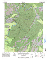
1995 Map of Clover Lick
USGS Topo · Published 1998About this map
Greenbrier River meanders sharply through the central portion of this map, carving deep bends around Rabbit Knob and past the riverside settlement of Clover Lick. This landscape is heavily defined by public timberlands, with the Seneca State Forest and Monongahela National Forest covering vast tracts of high ground like Thomas Mountain and Michael Mountain. Small rural centers and family-named landmarks are scattered throughout the valleys, providing a detailed record of late 20th-century life in the Greenbank District.
Find a feature on this map
58 named features on this map. Tap any name to fly to it.
Don’t see what you’re looking for? This feature index may not catch every label — zoom into the map to look around manually.
Map Details
Editions of this 1995 Clover Lick Map
This is the sole edition of this map. No revisions or reprints were ever made.
Other maps of this area

1891 · Huntersville
USGS Topo · 1:125,000

1894 · Huntersville
USGS Topo · 1:125,000

1901 · Monterey
USGS Topo · 1:125,000

1922 · Cass
USGS Topo · 1:48,000

1923 · Marlinton
USGS Topo · 1:48,000

1923 · Warm Springs
USGS Topo · 1:48,000

1923 · Mingo
USGS Topo · 1:48,000

1924 · Cass
USGS Topo · 1:62,500

1925 · Mingo
USGS Topo · 1:62,500

1925 · Marlinton
USGS Topo · 1:62,500