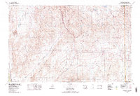
1978 Map of Clover Mts
USGS Topo · Published 1978About this map
The Union Pacific railroad cuts through the heart of this high-desert landscape, following the narrow corridors of Rainbow Canyon and Kane Springs Wash to connect isolated settlements like Elgin and Carp. This region of Lincoln County is dominated by massive mountain blocks, including the Clover Mountains and the Mormon Mountains, which hem in expansive arid basins such as the Delamar Valley and the Tule Desert. At the edge of the South Pahroc Range, the dry bed of Delamar Lake serves as a prominent landmark for the western valley.
Find a feature on this map
49 named features on this map. Tap any name to fly to it.
Don’t see what you’re looking for? This feature index may not catch every label — zoom into the map to look around manually.
Map Details
Editions of this 1978 Clover Mts Map
2 editions found

Other maps of this area

1885 · St. George
USGS Topo · 1:250,000

1885 · Pioche
USGS Topo · 1:250,000

1886 · Saint Thomas
USGS Topo · 1:250,000

1886 · Mt. Trumbull
USGS Topo · 1:250,000

1886 · Pioche
USGS Topo · 1:250,000

1891 · St. George
USGS Topo · 1:250,000

1892 · Mt. Trumbull
USGS Topo · 1:250,000

1893 · Saint Thomas
USGS Topo · 1:250,000

1907 · Las Vegas
USGS Topo · 1:250,000

1908 · Las Vegas
USGS Topo · 1:250,000