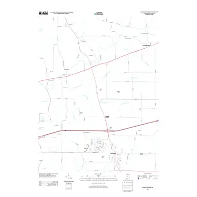
2013 Map of Cloverdale
USGS Topo · Published 2013About this map
Cloverdale serves as the primary hub of this Putnam County landscape, where modern transportation corridors intersect a terrain defined by subtle ridges and winding creek systems. The map illustrates a transitional rural environment characterized by a series of named elevations such as Snyder Hill, Hadden Hill, and Hughes Hill. These topographic features directed the early path of local roads and the placement of older settlements like Putnamville and Westland. A notable geologic landmark, the Devils Backbone, stands near Little Deer Cr in the northeast, while the southern reach of the quadrangle is marked by the small-scale aviation infrastructure of Clover Knoll Airport and the Sanders Gyroport. The drainage patterns of Limestone Cr and Mosquito Cr further carve the agricultural fields, revealing the persistent influence of the natural hydrology on land use and property boundaries in the early 21st century.
Find a feature on this map
109 named features on this map. Tap any name to fly to it.
Don’t see what you’re looking for? This feature index may not catch every label — zoom into the map to look around manually.
Map Details
Editions of this 2013 Cloverdale Map
This is the sole edition of this map. No revisions or reprints were ever made.
Other maps of this area

1949 · Quincy
USGS Topo · 1:24,000

1951 · Clinton Falls
USGS Topo · 1:24,000

1952 · Reelsville
USGS Topo · 1:24,000

1953 · Indianapolis
USGS Topo · 1:250,000

1956 · Indianapolis
USGS Topo · 1:250,000

1956 · Cloverdale
USGS Topo · 1:24,000

1956 · Cataract
USGS Topo · 1:24,000

1956 · Eminence
USGS Topo · 1:24,000

1957 · Indianapolis
USGS Topo · 1:250,000
1957 · Poland
USGS Topo · 1:24,000