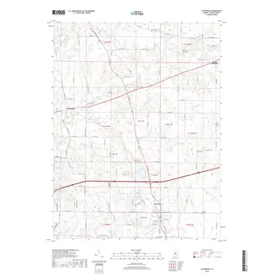
2019 Map of Cloverdale
USGS Topo · Published 2019About this map
Cloverdale sits at a crossroads of Putnam County, where the Interstate 70 corridor bisects the older north-south path of US Highway 231. This 2019 survey captures the community’s layout alongside smaller historic settlements like Putnamville and Mount Meridian. The landscape is defined by the winding course of Deer Creek and its many tributaries, such as Owl Br and Wallace Br, which cut through the limestone-rich terrain. Several distinctive ridges and peaks rise above the valleys, most notably the aptly named Devils Backbone and Hughes Hill.
Find a feature on this map
115 named features on this map. Tap any name to fly to it.
Don’t see what you’re looking for? This feature index may not catch every label — zoom into the map to look around manually.
Map Details
Editions of this 2019 Cloverdale Map
This is the sole edition of this map. No revisions or reprints were ever made.
Other maps of this area

1949 · Quincy
USGS Topo · 1:24,000

1951 · Clinton Falls
USGS Topo · 1:24,000

1952 · Reelsville
USGS Topo · 1:24,000

1953 · Indianapolis
USGS Topo · 1:250,000

1956 · Indianapolis
USGS Topo · 1:250,000

1956 · Cloverdale
USGS Topo · 1:24,000

1956 · Cataract
USGS Topo · 1:24,000

1956 · Eminence
USGS Topo · 1:24,000

1957 · Indianapolis
USGS Topo · 1:250,000
1957 · Poland
USGS Topo · 1:24,000