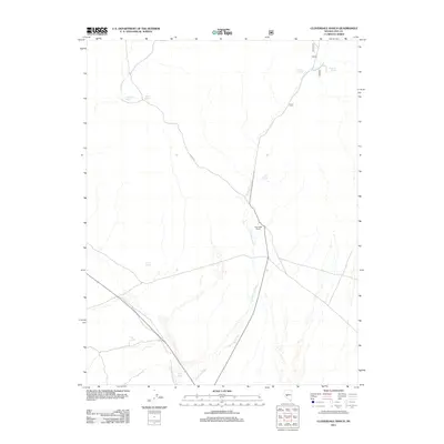
2011 Map of Cloverdale Ranch
USGS Topo · Published 2011About this map
Cloverdale Ranch serves as a primary point of human activity in this arid central Nevada landscape, situated at the confluence of several desert tracks and the intermittent flow of Cloverdale Creek. The map documents a survival-driven geography defined by isolated water sources, including Rojo Spring, Yellow Spring, and Red Spring, which appear as critical waypoints for local livestock or travelers through the Nye County wilderness. Arroyos like Golden Wash and Ione Wash carve through the basin, illustrating the drainage patterns that dominate the terrain surrounding the ranch. The road network is sparse, with Nfd 427 Rd providing one of the few named forest service access points into the northern reaches where Stevens Spring and Fourmile Spring are located. This survey preserves the remote pastoral and hydrologic character of the region in the early twenty-first century.
Find a feature on this map
12 named features on this map. Tap any name to fly to it.
Don’t see what you’re looking for? This feature index may not catch every label — zoom into the map to look around manually.
Map Details
Editions of this 2011 Cloverdale Ranch Map
This is the sole edition of this map. No revisions or reprints were ever made.
Other maps of this area

1907 · Tonopah
USGS Topo · 1:250,000

1908 · Tonopah
USGS Topo · 1:250,000

1956 · Tonopah
USGS Topo · 1:250,000

1959 · Tonopah
USGS Topo · 1:250,000

1962 · Tonopah
USGS Topo · 1:250,000

1964 · San Antonio Ranch
USGS Topo · 1:62,500

1980 · Cole Spring
USGS Topo · 1:24,000
1980 · Cloverdale Ranch
USGS Topo · 1:24,000
1980 · Outlaw Springs NE
USGS Topo · 1:24,000
1980 · Black Spring NW
USGS Topo · 1:24,000