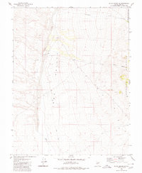
1980 Map of Black Spring NW
USGS Topo · Published 1980About this map
Ione Valley dominates this high-desert landscape in Nye County, flanked to the east by the rising slopes of the Shoshone Mountains. This 1980 edition, based on field work from the mid-1970s, illustrates the drainage patterns of the Great Basin, where Ione Wash and Cottonwood Creek flow through the arid basin floor. The northeastern portion of the map is defined by the protected boundary of the Toiyabe National Forest, where the terrain transitions into the steeper elevations of Indian Canyon. Human activity is marked primarily by infrastructure suited for remote exploration, including a network of Jeep Trails and a designated Borrow Pit. The map captures a moment of topographical precision just before the digital era, detailing the precise contours of this expansive Nevada valley and its mountain backdrop.
Find a feature on this map
10 named features on this map. Tap any name to fly to it.
Don’t see what you’re looking for? This feature index may not catch every label — zoom into the map to look around manually.
Map Details
Editions of this 1980 Black Spring NW Map
This is the sole edition of this map. No revisions or reprints were ever made.
Other maps of this area

1907 · Tonopah
USGS Topo · 1:250,000

1908 · Tonopah
USGS Topo · 1:250,000

1948 · Paradise Peak
USGS Topo · 1:62,500

1948 · Ione
USGS Topo · 1:62,500

1950 · Paradise Peak
USGS Topo · 1:62,500

1950 · Ione
USGS Topo · 1:62,500

1956 · Tonopah
USGS Topo · 1:250,000

1959 · Tonopah
USGS Topo · 1:250,000

1962 · Tonopah
USGS Topo · 1:250,000
1979 · Goldyke
USGS Topo · 1:24,000