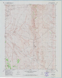
1979 Map of Goldyke
USGS Topo · Published 1980About this map
Mining vestiges and defunct camps define this high desert landscape on the border of Nye and Mineral Counties during the late 1970s. The map documents the remnants of three distinct settlements that have reverted to archaeological locations, including Atwood, Goldyke, and Pactolus. These sites, once centers of activity in the Pactolus Hills, are connected by a network of unimproved tracks and a Jeep Trail, reflecting the area's transition from active extraction to a quiet, weathered terrain. Evidence of the region's industrial past is scattered throughout the hills in the form of multiple Mines, a Mine Dump, and numerous Prospect pits. Natural drainage is marked by the seasonal path of Antone Wash, which cuts across the western slopes toward the broad Ione Valley.
Find a feature on this map
14 named features on this map. Tap any name to fly to it.
Don’t see what you’re looking for? This feature index may not catch every label — zoom into the map to look around manually.
Map Details
Editions of this 1979 Goldyke Map
This is the sole edition of this map. No revisions or reprints were ever made.
Other maps of this area

1907 · Tonopah
USGS Topo · 1:250,000

1908 · Tonopah
USGS Topo · 1:250,000

1948 · Paradise Peak
USGS Topo · 1:62,500

1948 · Ione
USGS Topo · 1:62,500

1950 · Paradise Peak
USGS Topo · 1:62,500

1950 · Ione
USGS Topo · 1:62,500

1956 · Tonopah
USGS Topo · 1:250,000

1959 · Tonopah
USGS Topo · 1:250,000

1962 · Tonopah
USGS Topo · 1:250,000
1979 · Stewart Spring
USGS Topo · 1:24,000