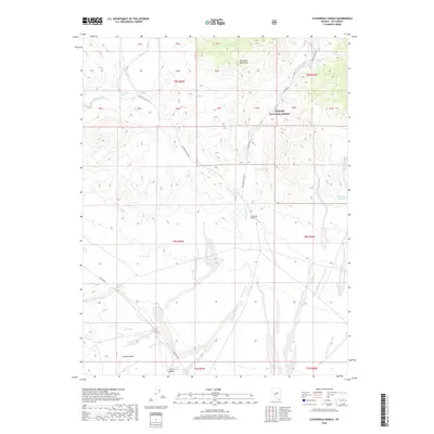
2018 Map of Cloverdale Ranch
USGS Topo · Published 2018About this map
Cloverdale Ranch sits as a lonely outpost within the high desert landscape of central Nevada, situated where Cloverdale Creek emerges from the Shoshone Mountains. This 2018 survey documents a region defined by water scarcity and vast topography, where the boundaries of the Toiyabe National Forest encompass numerous natural springs vital to local history. In the southern portion of the quadrangle, the Royston Hills give way to the Ione Valley, a broad expanse drained by the Ione Wash. The map details a network of forest development roads and the established Poleline Rd, which provide access to reliable water sources like Mississippi Springs, Yellow Spring, and Red Spring. This landscape reveals the importance of mountain drainage systems in supporting the historic ranching operations of Nye County.
Find a feature on this map
26 named features on this map. Tap any name to fly to it.
Don’t see what you’re looking for? This feature index may not catch every label — zoom into the map to look around manually.
Map Details
Editions of this 2018 Cloverdale Ranch Map
This is the sole edition of this map. No revisions or reprints were ever made.
Other maps of this area

1907 · Tonopah
USGS Topo · 1:250,000

1908 · Tonopah
USGS Topo · 1:250,000

1956 · Tonopah
USGS Topo · 1:250,000

1959 · Tonopah
USGS Topo · 1:250,000

1962 · Tonopah
USGS Topo · 1:250,000

1964 · San Antonio Ranch
USGS Topo · 1:62,500

1980 · Cole Spring
USGS Topo · 1:24,000
1980 · Cloverdale Ranch
USGS Topo · 1:24,000
1980 · Outlaw Springs NE
USGS Topo · 1:24,000
1980 · Black Spring NW
USGS Topo · 1:24,000