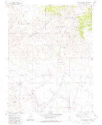
1980 Map of Cloverdale Ranch
USGS Topo · Published 1980About this map
Cloverdale Ranch serves as the central landmark in this high-desert landscape of Nye County, where the southern reaches of the Shoshone Mountains meet the broad expanse of the Big Smoky Valley. This 1980 survey reveals a region defined by its water sources and mineral interests, with numerous springs such as Rojo Spring, Yellow Spring, and Fourmile Spring punctuating the arid terrain. The map documents the industrial history of the Royston Hills, specifically highlighting the Orizaba Mine and a nearby Prospect, both connected by a network of unimproved roads and a Jeep Trail. Large portions of the northern and eastern territory fall within the Toiyabe National Forest, where Cloverdale Creek and Golden Wash carve drainage patterns through the rugged elevations before descending toward the valley floor.
Find a feature on this map
20 named features on this map. Tap any name to fly to it.
Don’t see what you’re looking for? This feature index may not catch every label — zoom into the map to look around manually.
Map Details
Editions of this 1980 Cloverdale Ranch Map
This is the sole edition of this map. No revisions or reprints were ever made.
Other maps of this area

1907 · Tonopah
USGS Topo · 1:250,000

1908 · Tonopah
USGS Topo · 1:250,000

1956 · Tonopah
USGS Topo · 1:250,000

1959 · Tonopah
USGS Topo · 1:250,000

1962 · Tonopah
USGS Topo · 1:250,000

1964 · San Antonio Ranch
USGS Topo · 1:62,500

1980 · Cole Spring
USGS Topo · 1:24,000
1980 · Outlaw Springs NE
USGS Topo · 1:24,000
1980 · Black Spring NW
USGS Topo · 1:24,000

1980 · Secret Basin
USGS Topo · 1:24,000