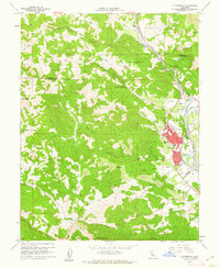
1960 Map of Cloverdale
USGS Topo · Published 1962About this map
Cloverdale serves as the primary hub of this northern Sonoma County landscape, situated where the Russian River flows between the Oat Valley and Alexander Valley. The town's grid, featuring West Main St and Washington St, sits just west of the Northwestern Pacific railroad line, which follows the river's path northward toward Preston. Outside the developed center, the topography rises sharply into the surrounding peaks, including Red Mtn and Thompson Ridge.
Find a feature on this map
51 named features on this map. Tap any name to fly to it.
Don’t see what you’re looking for? This feature index may not catch every label — zoom into the map to look around manually.
Map Details
Editions of this 1960 Cloverdale Map
4 editions found
Other maps of this area

1920 · Healdsburg
USGS Topo · 1:62,500

1921 · Skaggs
USGS Topo · 1:62,500

1921 · Kelseyville
USGS Topo · 1:62,500

1933 · Healdsburg
USGS Topo · 1:48,000

1938 · Hopland
USGS Topo · 1:62,500

1940 · Healdsburg
USGS Topo · 1:62,500

1943 · Tombs Creek
USGS Topo · 1:24,000

1943 · Skaggs Springs
USGS Topo · 1:24,000

1943 · Kelseyville
USGS Topo · 1:62,500

1943 · Hopland
USGS Topo · 1:62,500