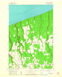
1961 Map of Cloverland
USGS Topo · Published 1962About this map
Lake Superior dominates the northern horizon of this Douglas County coastal landscape, where the shoreline meets a series of drainages carving through the timbered terrain. The map captures a moment when small rural hubs like Cloverland and the southern settlement near Maple Ch served as the primary points of community life. Several family-named waterways, including Haukkala Creek, Pearson Creek, and Anderson Creek, flow northward toward the great lake, revealing a drainage pattern that influenced early land use and settlement placement.
Find a feature on this map
17 named features on this map. Tap any name to fly to it.
Don’t see what you’re looking for? This feature index may not catch every label — zoom into the map to look around manually.
Map Details
Editions of this 1961 Cloverland Map
2 editions found
Other maps of this area

1947 · Brule
USGS Topo · 1:48,000

1949 · Poplar
USGS Topo · 1:48,000

1953 · Ashland
USGS Topo · 1:250,000

1954 · Lake Nebagamon
USGS Topo · 1:24,000

1954 · Poplar NE
USGS Topo · 1:24,000

1954 · Poplar
USGS Topo · 1:24,000

1954 · Cloverland
USGS Topo · 1:24,000

1958 · Ashland
USGS Topo · 1:250,000
1961 · Lake Nebagamon
USGS Topo · 1:24,000
1961 · Brule
USGS Topo · 1:62,500