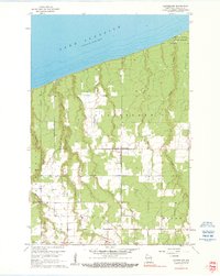
1961 Map of Cloverland
USGS Topo · Published 1990About this map
Lake Superior dominates the northern horizon of this coastal Douglas County landscape, where the shoreline meets a terrain carved by numerous north-flowing waterways. This 1961 revision of earlier 1950s data captures the rural character of the region as it transitions from the forested grounds of the Brule River State Forest in the northeast toward the agricultural clearings of the Cloverland and Maple townships. The map reveals a drainage pattern defined by parallel streams such as Haukkala Creek, Pearson Creek, and Smith Creek, which cut through the rising elevation away from the lake.
Find a feature on this map
16 named features on this map. Tap any name to fly to it.
Don’t see what you’re looking for? This feature index may not catch every label — zoom into the map to look around manually.
Map Details
Editions of this 1961 Cloverland Map
2 editions found
Other maps of this area

1947 · Brule
USGS Topo · 1:48,000

1949 · Poplar
USGS Topo · 1:48,000

1953 · Ashland
USGS Topo · 1:250,000

1954 · Lake Nebagamon
USGS Topo · 1:24,000

1954 · Poplar NE
USGS Topo · 1:24,000

1954 · Poplar
USGS Topo · 1:24,000

1954 · Cloverland
USGS Topo · 1:24,000

1958 · Ashland
USGS Topo · 1:250,000
1961 · Cloverland
USGS Topo · 1:24,000
1961 · Lake Nebagamon
USGS Topo · 1:24,000