
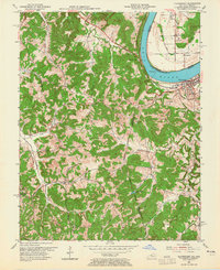
1953 Map of Cloverport
USGS Topo · Published 1955About this map
The Ohio River dominates the northern landscape of this 1950s survey, marking the state line between Kentucky and Indiana. In Kentucky, the town of Cloverport sits as a primary riverfront hub, while across the water in Indiana, Tobinsport serves as a counterpart. The interior terrain is deeply dissected by a network of waterways including Blackford Creek, Caney Creek, and Fawcett Creek, which have carved out the steep topography of Tuckers Ridge and Shafer Hill.
Find a feature on this map
39 named features on this map. Tap any name to fly to it.
Don’t see what you’re looking for? This feature index may not catch every label — zoom into the map to look around manually.
Map Details
Editions of this 1953 Cloverport Map
2 editions found
Other maps of this area

1903 · Tell City
USGS Topo · 1:62,500

1907 · Whitesville
USGS Topo · 1:62,500

1909 · Whitesville
USGS Topo · 1:62,500

1932 · Fordsville
USGS Topo · 1:62,500

1934 · Cannelton
USGS Topo · 1:62,500

1949 · Cannelton
USGS Topo · 1:24,000

1953 · Cannelton
USGS Topo · 1:24,000

1953 · Whitesville
USGS Topo · 1:24,000

1953 · Tell City
USGS Topo · 1:24,000
1953 · Mattingly
USGS Topo · 1:24,000