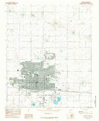
1985 Map of Clovis
USGS Topo · Published 1985About this map
Clovis serves as the focal point of this High Plains survey, showcasing the city's significant rail infrastructure and urban expansion. The extensive Clovis Ground rail yards and multiple Elevator sites emphasize the town's role as a critical transportation and agricultural hub in Curry County. Beyond the grid of city streets, the landscape is punctuated by utility and communication markers, including a Double Wooden Power Line and various Radio Towers.
Find a feature on this map
20 named features on this map. Tap any name to fly to it.
Don’t see what you’re looking for? This feature index may not catch every label — zoom into the map to look around manually.
Map Details
Editions of this 1985 Clovis Map
This is the sole edition of this map. No revisions or reprints were ever made.
Other maps of this area

1954 · Clovis
USGS Topo · 1:250,000

1957 · Portair
USGS Topo · 1:62,500

1957 · Clovis
USGS Topo · 1:62,500

1957 · Pleasant Hill
USGS Topo · 1:62,500

1957 · Hammond Ranch
USGS Topo · 1:62,500

1958 · Clovis
USGS Topo · 1:250,000

1985 · Portair
USGS Topo · 1:24,000

1985 · Midway
USGS Topo · 1:24,000

1985 · Pleasure Lake
USGS Topo · 1:24,000

1985 · Pleasant Hill
USGS Topo · 1:24,000