
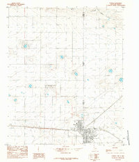
1985 Map of Pleasant Hill
USGS Topo · Published 1985About this map
Pleasant Hill serves as the central hub of this agricultural landscape along the high plains border in the mid-1980s. The terrain is defined by the subtle, winding depressions of ephemeral watercourses, including Mustang Draw to the north and Catfish Draw in the east. These drainages, along with Running Water Draw at the southern edge, illustrate the characteristic hydrology of the Llano Estacado, where surface water is scarce and drainage patterns are often discontinuous. Straddling the state line between New Mexico and Texas, the map reveals a rigid grid of section lines and rural tracks that governed settlement and land use. The boundary between Curry County and Parmer County bisects the area, highlighting the intersection of regional jurisdictions in this quiet corner of the borderlands.
Find a feature on this map
6 named features on this map. Tap any name to fly to it.
Don’t see what you’re looking for? This feature index may not catch every label — zoom into the map to look around manually.
Map Details
Editions of this 1985 Pleasant Hill Map
This is the sole edition of this map. No revisions or reprints were ever made.
Other maps of this area

1954 · Clovis
USGS Topo · 1:250,000

1957 · Clovis
USGS Topo · 1:62,500

1957 · Pleasant Hill
USGS Topo · 1:62,500

1958 · Clovis
USGS Topo · 1:250,000

1963 · Oklahoma Lane
USGS Topo · 1:24,000

1965 · Bovina
USGS Topo · 1:24,000

1965 · Rhea
USGS Topo · 1:24,000

1985 · Pleasant Hill NW
USGS Topo · 1:24,000

1985 · Muleshoe
USGS Topo · 1:100,000
1985 · Farwell
USGS Topo · 1:24,000