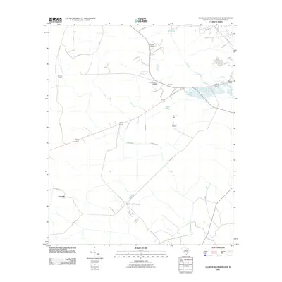
2011 Map of Clubhouse Crossroads
USGS Topo · Published 2011About this map
Clubhouse Crossroads serves as a central junction in this rural Dorchester County landscape, where the lowcountry terrain is defined by the winding path of the Ashley River and its associated wetlands. The map documents several small, scattered communities including Coachmans Corners, Canaan, and Gettysville, reflecting a settlement pattern deeply tied to the local road network and drainage systems like Fishburne Creek and Scotts Creek. Local genealogy and land use are well-represented by the inclusion of multiple family or community burial sites, such as Beech Hill Cemetery, Magnolia Cemetery, and Rosom Hill Cemetery. The transition from riverine environments to higher ground is evident at Rosom Hill, while landmarks like Slands Bridge and the marshy area known as The Forks emphasize the importance of water crossings and confluence points in the South Carolina interior during the early 21st century.
Find a feature on this map
47 named features on this map. Tap any name to fly to it.
Don’t see what you’re looking for? This feature index may not catch every label — zoom into the map to look around manually.
Map Details
Editions of this 2011 Clubhouse Crossroads Map
This is the sole edition of this map. No revisions or reprints were ever made.
Other maps of this area

1918 · Cottageville
USGS Topo · 1:62,500

1919 · Summerville
USGS Topo · 1:48,000

1919 · Ridgeville
USGS Topo · 1:48,000

1920 · Ravenels
USGS Topo · 1:62,500

1920 · Ridgeville
USGS Topo · 1:62,500

1920 · Summerville
USGS Topo · 1:62,500

1943 · Cottageville
USGS Topo · 1:62,500

1943 · Ridgeville
USGS Topo · 1:62,500

1944 · Ravenels
USGS Topo · 1:62,500

1944 · Summerville
USGS Topo · 1:62,500