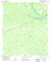
1979 Map of Clubhouse Crossroads
USGS Topo · Published 1991About this map
Cypress and Ashley swamp waters dominate the northeastern landscape of this Dorchester County region, where the River flows past Schultz Lake and under Sands Bridge. The terrain is defined by low-lying wetlands and subtle elevations like Beech Hill and Rosom Hill. Settlement patterns are dispersed, centered on historic intersections and rural communities such as Clubhouse Crossroads, Knightsville, and Gettysville. The map reveals a network of local institutions essential to these communities, including Givhans Sch and several houses of worship such as Knightsville Ch and Sand Hill Ch. Land use is characterized by a mix of agricultural tracts, such as Cane Acre, and timbered areas cut by Fishburne Creek and Scotts Branch. Several family and community burial grounds, notably Magnolia Cem and Shepherd Grove Cem, are preserved across the lowcountry flats.
Find a feature on this map
34 named features on this map. Tap any name to fly to it.
Don’t see what you’re looking for? This feature index may not catch every label — zoom into the map to look around manually.
Map Details
Editions of this 1979 Clubhouse Crossroads Map
This is the sole edition of this map. No revisions or reprints were ever made.
Other maps of this area

1918 · Cottageville
USGS Topo · 1:62,500

1919 · Summerville
USGS Topo · 1:48,000

1919 · Ridgeville
USGS Topo · 1:48,000

1920 · Ravenels
USGS Topo · 1:62,500

1920 · Ridgeville
USGS Topo · 1:62,500

1920 · Summerville
USGS Topo · 1:62,500

1943 · Cottageville
USGS Topo · 1:62,500

1943 · Ridgeville
USGS Topo · 1:62,500

1944 · Ravenels
USGS Topo · 1:62,500

1944 · Summerville
USGS Topo · 1:62,500