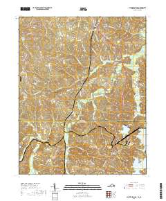
2019 Map of Cluster Springs
USGS Topo · Published 2019About this map
Cluster Springs and Denniston anchor this landscape along the border of Halifax County, Virginia, and Person County, North Carolina. The terrain is defined by the winding course of the Hyco River and the expansive waters of the Mayo Reservoir to the southeast. For genealogists and local historians, the area is rich with family and community markers, including the Black Walnut Cem, Spring Hill Cem, and Montague Cem. The spiritual life of the borderlands is mapped through landmarks like the Bethel Hill Baptist Church Cem and Baileys Chapel Methodist Church Cem. North of Harmony, the small Vaughan Airport provides a point of modern infrastructure amidst the creek-fed hills. Numerous small tributaries such as Stokes Cr, Coleman Cr, and Crutchfield Br drain into the primary river systems, shaping the settlement patterns of historic communities like Mayo and Cedar Grove.
Find a feature on this map
85 named features on this map. Tap any name to fly to it.
Don’t see what you’re looking for? This feature index may not catch every label — zoom into the map to look around manually.
Map Details
Editions of this 2019 Cluster Springs Map
This is the sole edition of this map. No revisions or reprints were ever made.
Other maps of this area

1943 · Roxboro
USGS Topo · 1:62,500

1952 · Milton
USGS Topo · 1:62,500

1953 · South Boston
USGS Topo · 1:62,500

1953 · Greensboro
USGS Topo · 1:250,000

1954 · Greensboro
USGS Topo · 1:250,000

1956 · Milton
USGS Topo · 1:62,500

1957 · South Boston
USGS Topo · 1:62,500

1962 · Greensboro
USGS Topo · 1:250,000

1966 · Greensboro
USGS Topo · 1:250,000
1968 · Alton
USGS Topo · 1:24,000