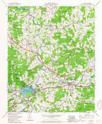
1967 Map of Clyde
USGS Topo · Published 1967About this map
Lake Junaluska serves as a prominent focal point in this 1967 survey of Haywood County, featuring its swimming pool and youth center at the heart of the landscape. To the west, Waynesville and Barberville mark the edge of a growing mountain community, while the Pigeon River snakes through the center of the sheet, followed closely by the Southern railway line. The map highlights a transition from established valley settlements like Clyde to the protected boundaries of the Pisgah National Forest, where peaks like Goat Knob and Cansadie Top rise above the coves.
Find a feature on this map
138 named features on this map. Tap any name to fly to it.
Don’t see what you’re looking for? This feature index may not catch every label — zoom into the map to look around manually.
Map Details
Editions of this 1967 Clyde Map
3 editions found
Other maps of this area

1891 · Cowee
USGS Topo · 1:125,000

1893 · Mt Guyot
USGS Topo · 1:125,000

1894 · Asheville
USGS Topo · 1:125,000

1897 · Cowee
USGS Topo · 1:125,000

1901 · Asheville
USGS Topo · 1:125,000

1905 · Pisgah
USGS Topo · 1:125,000

1906 · Pisgah
USGS Topo · 1:125,000

1907 · Cowee
USGS Topo · 1:125,000

1912 · Mt Guyot
USGS Topo · 1:125,000

1935 · Cruso
USGS Topo · 1:24,000