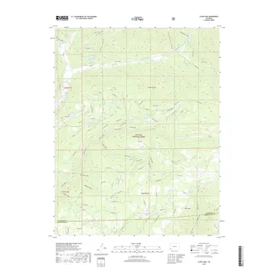
2019 Map of Clyde Lake
USGS Topo · Published 2019About this map
San Juan National Forest encompasses this high-altitude landscape along the border of Dolores and Montezuma counties. The terrain is defined by a series of prominent mesas and deep drainages, with Stoner Mesa and Taylor Mesa serving as broad plateaus between the carved paths of Stoner Creek and Taylor Cr. This region is characterized by an extensive system of water management features, including Clyde Lake Reservoir, Cattail Reservoir, and Juan Spring Reservoir, which reflect the area's historical and ongoing reliance on managed alpine water sources for livestock and land management.
Find a feature on this map
70 named features on this map. Tap any name to fly to it.
Don’t see what you’re looking for? This feature index may not catch every label — zoom into the map to look around manually.
Map Details
Editions of this 2019 Clyde Lake Map
This is the sole edition of this map. No revisions or reprints were ever made.
Other maps of this area

1897 · Rico
USGS Topo · 1:62,500

1898 · Rico
USGS Topo · 1:62,500

1899 · Rico
USGS Topo · 1:62,500

1953 · Dolores Peak
USGS Topo · 1:24,000

1956 · Cortez
USGS Topo · 1:250,000

1958 · Cortez
USGS Topo · 1:250,000

1959 · Cortez
USGS Topo · 1:250,000
1960 · Rico
USGS Topo · 1:24,000

1962 · Cortez
USGS Topo · 1:250,000

1963 · Stoner
USGS Topo · 1:24,000