
1941 Map of Coachella
USGS Topo · Published 1956About this map
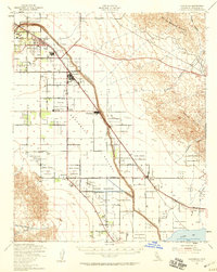
The Coachella Valley landscape in the early 1940s is defined by a rigorous grid of agriculture and irrigation concentrated between the Southern Pacific tracks and the base of the Mecca Hills. At this time, the region was evolving from a railroad-centric desert outpost into a productive citrus and date-growing hub. The map captures the significant footprint of tribal lands, including the Augustine Indian Reservation and the sprawling Torres Martinez Indian Reservation, which surround small settlements like Thermal and Valerie. To the southeast, the shoreline of the Salton Sea appears near a specialized Salt Works and the railroad stop at Caleb. The presence of the Whitewater River and the Storm Channel underscores the persistent efforts to manage water in this arid basin, providing a detailed look at the infrastructure that supported towns like Coachella and Indio during the mid-twentieth century.
Find a feature on this map
34 named features on this map. Tap any name to fly to it.
Don’t see what you’re looking for? This feature index may not catch every label — zoom into the map to look around manually.
Map Details
Editions of this 1941 Coachella Map
2 editions found
Other maps of this area

1904 · Indio
USGS Topo · 1:125,000

1931 · Vallecito
USGS Topo · 1:125,000

1940 · Cottonwood Spring
USGS Topo · 1:62,500

1940 · Durmid
USGS Topo · 1:62,500

1941 · Toro Peak
USGS Topo · 1:62,500

1941 · Clark Lake
USGS Topo · 1:62,500

1941 · Edom
USGS Topo · 1:62,500

1942 · Agua Dulce
USGS Topo · 1:62,500

1942 · Clark Lake
USGS Topo · 1:62,500

1943 · Vallecito
USGS Topo · 1:125,000