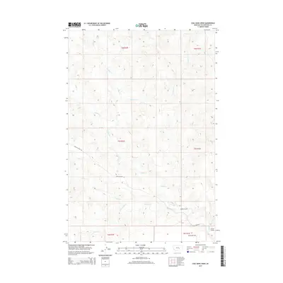
2014 Map of Coal Bank Creek
USGS Topo · Published 2014About this map
Coal Bank Cr and the complex drainage systems of the Yellowstone County high plains define this landscape. The map reveals an intricate network of seasonal watercourses, including Buffalo Cr, E Buffalo Cr, and Antelope Cr, which have carved distinct topographical features into the terrain. Notable landforms such as Sevenmile Flat contrast with the eroded depressions of Laylan Coulee and Carson Coulee. This 2014 survey documents the enduring pastoral character of the region, where the Public Land Survey System grid remains the primary organizing principle for movement. Transport is limited to established rural routes like Custer Pineview Rd and Buffalo Creek Rd, which traverse the open range between Dry Antelope Cr and the northern reaches of the quadrangle.
Find a feature on this map
16 named features on this map. Tap any name to fly to it.
Don’t see what you’re looking for? This feature index may not catch every label — zoom into the map to look around manually.
Map Details
Editions of this 2014 Coal Bank Creek Map
This is the sole edition of this map. No revisions or reprints were ever made.
Other maps of this area

1954 · Forsyth
USGS Topo · 1:250,000

1957 · Forsyth
USGS Topo · 1:250,000

1958 · Forsyth
USGS Topo · 1:250,000

1960 · Coal Bank Creek
USGS Topo · 1:24,000

1960 · Custer
USGS Topo · 1:24,000

1960 · Waco
USGS Topo · 1:24,000
1960 · Mission Creek
USGS Topo · 1:24,000
1967 · Bull Mountain
USGS Topo · 1:24,000

1979 · Hysham
USGS Topo · 1:100,000
1979 · Devils Kitchen
USGS Topo · 1:24,000