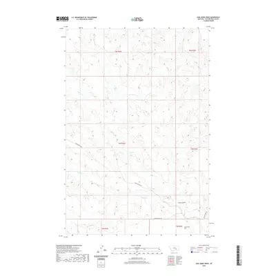
2020 Map of Coal Bank Creek
USGS Topo · Published 2020About this map
Coal Bank Cr and E Buffalo Cr carve through this section of the Montana landscape, defining a network of drainages that have long shaped local land use in Yellowstone County. The map captures a largely open, rural topography where water remains the primary landmark, including Antelope Cr and Laylan Coulee. The southern portion of the sheet is dominated by the level expanse of Sevenmile Flat, a distinct geographical feature that stands in contrast to the surrounding dissected terrain.
Find a feature on this map
18 named features on this map. Tap any name to fly to it.
Don’t see what you’re looking for? This feature index may not catch every label — zoom into the map to look around manually.
Map Details
Editions of this 2020 Coal Bank Creek Map
This is the sole edition of this map. No revisions or reprints were ever made.
Other maps of this area

1954 · Forsyth
USGS Topo · 1:250,000

1957 · Forsyth
USGS Topo · 1:250,000

1958 · Forsyth
USGS Topo · 1:250,000

1960 · Coal Bank Creek
USGS Topo · 1:24,000

1960 · Custer
USGS Topo · 1:24,000

1960 · Waco
USGS Topo · 1:24,000
1960 · Mission Creek
USGS Topo · 1:24,000
1967 · Bull Mountain
USGS Topo · 1:24,000

1979 · Hysham
USGS Topo · 1:100,000
1979 · Devils Kitchen
USGS Topo · 1:24,000